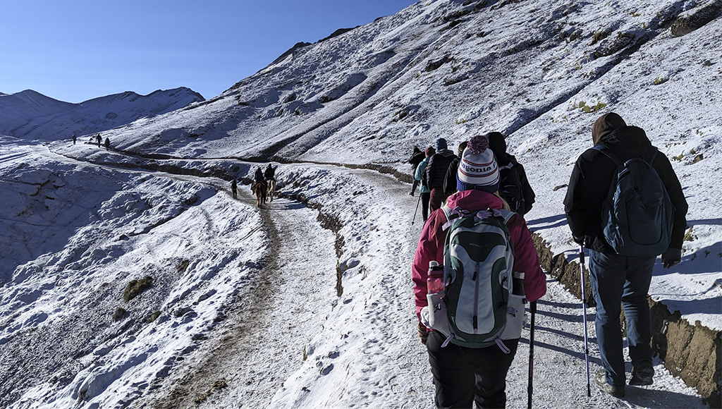
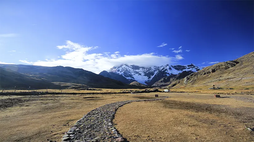
Hiking in Peru offers some of the best trekking routes in South America, from iconic trails like the Inca Trail and Salkantay to remote high-altitude treks in the Andes. These routes range from short scenic day hikes to demanding multi-day adventures, which makes the country a strong choice for different travel styles and fitness levels. For outdoor travelers, it is also one of the best things to do in Cusco and the surrounding region.
This guide covers Peru’s best treks and the key tips you need to choose the right route, pack well, and plan your trip with confidence
- Why Hiking in Peru Is Unique
- Best Treks in Peru
- How to Choose the Right Trek in Peru
- Best Time for Hiking in Peru
- What to Pack for Hiking in Peru
- Travel Tips for Hiking in Peru
- FAQs About Hiking in Peru
Why Hiking in Peru Is Unique
Peru is a top destination for hiking because the scenery changes quickly, from the Sacred Valley to high mountains, valleys, and remote villages. This variety allows travelers to choose routes that match their level, from short scenic hikes to demanding multi-day treks. The combination of natural beauty and cultural depth makes each trek feel distinct rather than repetitive.
Best Treks in Peru
Peru is home to some of South America’s most rewarding trekking places. Some routes, like the Inca Trail Peru, are world-famous, while others feel more remote and demanding. This Peru trekking guide will help you compare them by difficulty, scenery, duration, and overall experience.
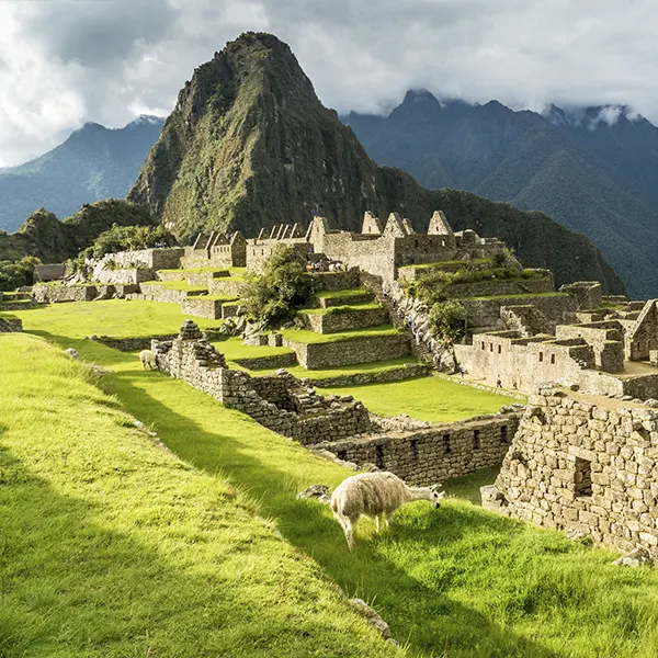
1. Inca Trail to Machu Picchu
The Inca Trail to Machu Picchu is one of the most famous hikes in Peru because it combines mountain scenery, important Inca ruins, and a direct arrival at the citadel through the Sun Gate. For many travelers, that final approach is the route’s biggest highlight, since it gives the experience a stronger historical feel and a more memorable finish than many other treks.
Another important factor is that travelers must book the route with an authorized operator, as independent hiking is not allowed. In addition, permits are limited and often sell out months in advance, especially during the dry season. The trail also closes every February for maintenance, so early planning is essential for anyone who wants to secure a place on the classic route.
- Duration: 4 days / 3 nights
- Distance: 43 km
- Elevation: Reaches about 4,215 masl at Warmiwañusca Pass
- Difficulty: Moderate to challenging
- Best for: Travelers who want a historic route with cultural sites, guided support, and a classic Machu Picchu arrival.
2. Salkantay Trek
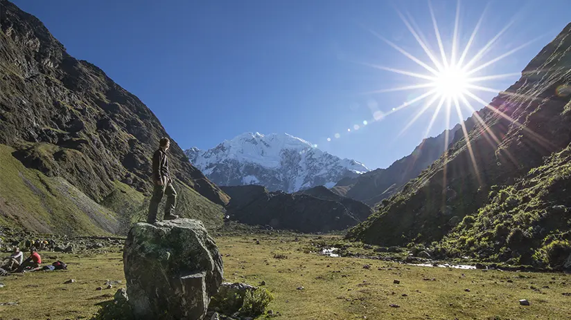
Set high in the Andes, the Salkantay Trek is one of the most popular alternative treks to Machu Picchu. Snowy peaks, mountain passes, and cloud forest views give this route more variety than many others in Peru. It suits travelers who want a bigger challenge and a more remote experience on the way to Machu Picchu.
Unlike the Inca Trail, this route does not focus on ancient Inca sites along the path. Its main draw is the scenery, which changes from cold alpine terrain to greener valleys as the trek moves forward. Many travelers choose it for its difficulty, wide mountain views, and quieter atmosphere.
- Duration: 4 to 5 days
- Distance: Around 70 km
- Elevation: Reaches about 4,630 masl at Salkantay Pass
- Difficulty: Challenging
- Best for: Travelers who want a demanding trek with diverse scenery and a less traditional route to Machu Picchu
3. Ausangate Trek
The Ausangate Trek is among the most remote routes in the Peruvian Andes because it lies far from the more popular trails near Machu Picchu. Snow-covered peaks, open valleys, turquoise lakes, and high mountain passes create a landscape that feels wilder and less traveled. This route suits hikers who want a tougher adventure in a mountain range setting with fewer crowds.
Unlike treks that end at a major landmark, the Ausangate trek Peru stands out for the journey itself. The trail passes through remote communities and high-altitude terrain. This allows travelers to experience daily life in the Andes. Many hikers choose it for its raw setting, long distances, and the chance to experience a more remote side of trekking in Peru.
- Duration: 5 to 6 days
- Distance: Around 65 to 70 km
- Elevation: Reaches over 5,000 masl at the highest passes
- Difficulty: Challenging
- Best for: Experienced hikers who want a remote high-altitude trek with dramatic mountain scenery
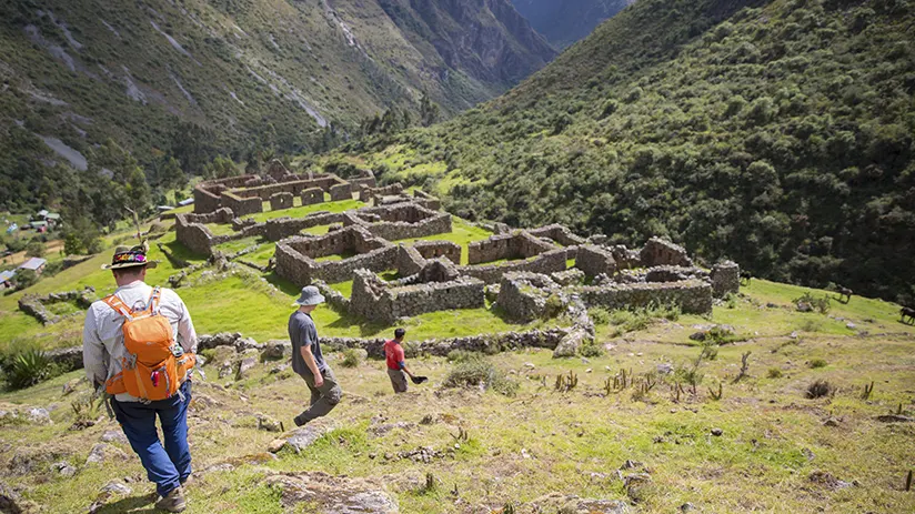
4. Choquequirao

Hidden deep above the Apurímac Canyon, Choquequirao offers one of the most rewarding long-distance routes in the country. Steep climbs, remote campsites, and wide canyon views make this trail feel far more isolated than the better-known paths near Machu Picchu. Many hikers choose the Choquequirao trek for its physical challenge, dramatic scenery, and low visitor numbers. It also leads to one of the region’s most important Inca sites.
Compared with more popular routes, this one feels quieter and more demanding from start to finish. Much of the appeal comes from the sense of remoteness, since the trail drops deep into the canyon before climbing back toward the ruins. Many travelers choose it for the effort, the solitude, and the chance to reach an important Inca site that still feels less explored.
- Duration: 4 to 5 days
- Distance: Around 64 km round trip
- Elevation: Reaches over 3,000 masl at the ruins, with major elevation loss and gain through the canyon
- Difficulty: Challenging
- Best for: Travelers who want a demanding route, fewer crowds, and a remote archaeological destination
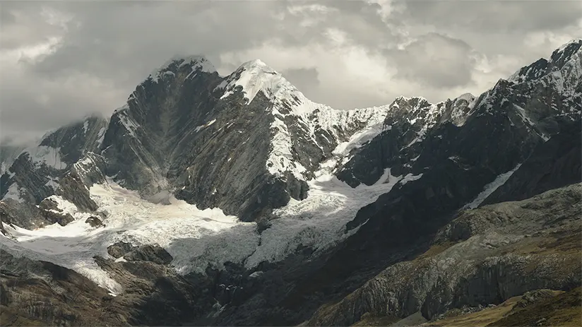
5. Santa Cruz
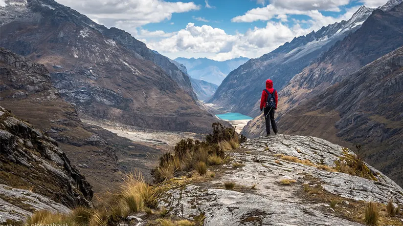
Set in the Cordillera Blanca, the Santa Cruz trek is one of the best-known routes outside southern Peru. Snowy peaks, glacial lakes, and broad alpine valleys give this trail a feel unlike the routes near Cusco. Many hikers choose it because it offers classic mountain scenery without the crowds found on more famous circuits.
This route stands out for its balance of scenery and accessibility. The path crosses high passes and open valleys, making it more consistent with some of Peru’s tougher multi-day routes. For travelers who want strong scenery and a true Andes experience, Santa Cruz is often one of the best hikes in Peru.
- Duration: 4 days / 3 nights
- Distance: Around 50 km
- Elevation: Reaches about 4,750 masl at Punta Unión Pass
- Difficulty: Moderate to challenging
- Best for: Travelers who want a scenic multi-day trek with high mountain views and less cultural focus than the routes near Cusco
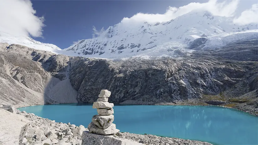
6. Laguna 69

Located in Huascarán National Park, Laguna 69 is one of the most famous day hikes in Peru. The route leads to a bright blue lake surrounded by steep peaks and high mountain walls. Many travelers choose this route for its scenery and shorter format. It also offers a chance to experience the Cordillera Blanca in a single day.
Among Peru’s top day hikes, this one stands out for its strong views and clear reward at the end. The climb can feel demanding because of the altitude, even though the route is shorter than a multi-day trek. For many travelers, Laguna 69 is a rewarding full-day mountain experience.
- Duration: Full day / around 5 to 6 hours of hiking
- Distance: Around 14 km round trip
- Elevation: Reaches about 4,600 masl
- Difficulty: Moderate to challenging
- Best for: Travelers who want a scenic day hike with a clear final destination and high mountain views
7. Humantay Lake

Set below snowy peaks in the Cusco region, Humantay Lake is a classic short route in the Andes. The trail leads to a bright turquoise lake that stands out against rocky slopes and glacier views. Many travelers choose the Humantay Lake hike for its scenery and shorter format.
The route is shorter than many others in the country, but the altitude still makes the climb feel demanding. Clear weather often brings the best views, especially early in the day.
- Duration: Half day to full day / around 1.5 to 3 hours of hiking
- Distance: Around 7 km round trip
- Elevation: Reaches about 4,200 masl
- Difficulty: Moderate
- Best for: Travelers who want a short high-altitude hike with strong views and a clear final destination
8. Rainbow Mountain
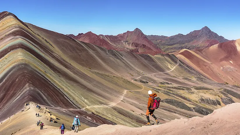
Known locally as Vinicunca, Rainbow Mountain is one of the most popular hikes near Cusco. The route leads to a high-altitude viewpoint with colorful mineral bands and wide Andean scenery. Many travelers choose the Rainbow Mountain for its unusual landscape and its shorter format.
The trail is short, but the altitude makes it feel harder than many visitors expect. Most travelers reach the hiking area after driving through Cusipata and then continue on foot toward the summit. Clear weather usually brings the best views, and many hikers add the nearby Red Valley if time and energy allow.
- Duration: Full day / around 2 hours up and 2 hours back on foot
- Distance: Around 7 km round trip
- Elevation: Reaches about 5,040 m
- Difficulty: Moderate to challenging
- Best for: Travelers who want a short high-altitude route with unique colors and strong mountain views
9. Huayhuash Trek
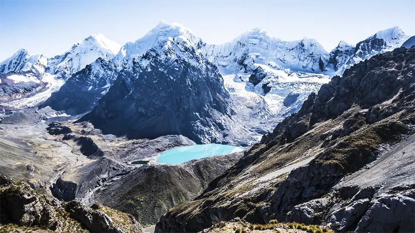
The Huayhuash Trek is one of the most demanding long-distance routes in South America. It takes hikers deep into a remote part of the Peruvian Andes. Snow-covered peaks, high passes, glacial lakes, and open valleys give the route a dramatic mountain setting from start to finish.
Shorter routes often build toward one main viewpoint, but Huayhuash stands out for the full journey. The trek lasts several days, crosses higher ground, and requires strong physical preparation. For experienced hikers, it offers one of the most complete mountain adventures in Peru.
- Duration: 8 to 12 days
- Distance: Around 115 to 130 km
- Elevation: Reaches over 5,000 masl at the highest passes
- Difficulty: Challenging
- Best for: Experienced hikers who want a long, remote trek with major mountain scenery and high-altitude passes
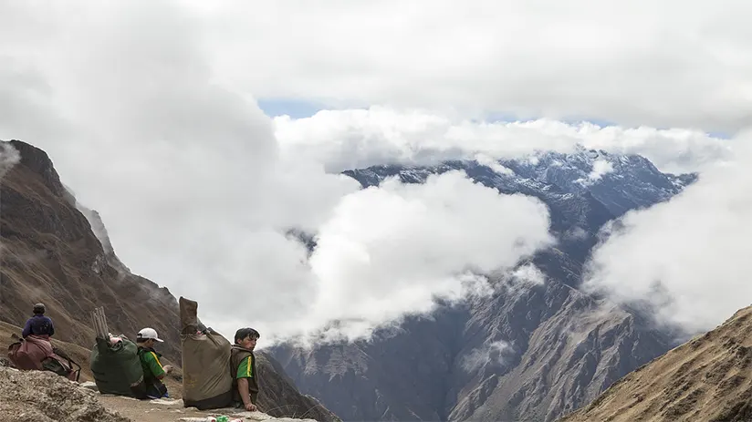
10. Colca Canyon

Colca Canyon offers a different hiking experience in southern Peru. Its dry canyon landscape feels distinct from the high alpine routes of the Andes. Many travelers choose it for its scenery, lower trekking altitude.
This route can still feel demanding because of the sharp descents and climbs, especially under warmer daytime conditions. Early starts are common, and many hikers also look for condor viewpoints as part of the experience. Colca Canyon is a strong option for travelers who want wide views and a different setting.
- Duration: 1 to 2 days
- Distance: Varies by route, often around 15 to 20 km
- Elevation: Usually between 2,000 masl and 3,600 masl, depending on the section
- Difficulty: Moderate to challenging
- Best for: Travelers who want canyon scenery, village stops, and a shorter trek outside the Cusco region
How to Choose the Right Trek in Peru
Choosing the right route depends on time, fitness level, and comfort with altitude. Some trails work well as day hikes, while others require several days, stronger endurance, and more planning. The table below gives a quick comparison of the main options, based on route type, difficulty, and the kind of experience each one offers.
| Strong options | If you want… | Best fit |
|---|---|---|
| Inca Trail to Machu Picchu | A classic route with history | A guided multi-day trek with cultural value |
| Salkantay Trek | A tougher route to Machu Picchu | A scenic multi-day trek with more variety |
| Ausangate Trek, Huayhuash Trek | A remote high-altitude challenge | A demanding trek with fewer crowds |
| Choquequirao | A quieter archaeological route | A long trek with steep climbs and a remote site |
| Santa Cruz | A scenic multi-day route outside Cusco | A classic Andes trek with mountain views |
| Laguna 69, Humantay Lake, Rainbow Mountain | A rewarding day hike | A shorter route with a strong final viewpoint |
| Colca Canyon | A different landscape | A trek with canyon views and village stops |
Best Time for Hiking in Peru

The best season for most routes in the Andes is the dry season, when trails are usually clearer and skies are more stable. In Peru, the dry season generally runs from May to September, while the rainy season is more common from November to March. for this reason, many travelers check the best time to visit Peru before choosing their travel dates. The table below outlines the main hiking seasons in Peru, including typical weather, trail conditions, and crowd levels.
| Season | Months | What to expect | Best for |
|---|---|---|---|
| Dry season | May to September | Clearer skies, firmer trails, colder nights at altitude | Most multi-day treks and high-altitude routes |
| Shoulder season | April and October | Mixed conditions, fewer crowds, some rain possible | Travelers who want flexibility and fewer people |
| Rainy season | November to March | Wetter trails, cloudier views, higher chance of disruption | Shorter plans with flexible timing |
| Peak trekking months | July and August | Strong conditions, but more visitors on popular routes | Travelers who book early and do not mind busier trails |
What to Pack for Hiking in Peru

Packing the right gear is essential for a safe and comfortable trek in Peru. High altitudes and changing weather mean your packing list must focus on utility and durability. The right gear will help you stay comfortable throughout the trek.
- Layered clothing: A base layer, a warm mid-layer, and a light outer shell work better than one heavy jacket.
- Waterproof jacket: Even in the dry season, the weather can change quickly in the mountains.
- Good hiking shoes: Trails often include loose ground, steep sections, and uneven paths.
- Sun protection: Bring sunscreen, sunglasses, and a hat, since high-altitude sun can be intense.
- Water and snacks: Hydration matters even more at altitude, and extra snacks help on longer climbs.
- Small daypack: A compact backpack is enough for water, layers, and personal items on most day hikes.
- Trekking poles: These are especially helpful on steep ascents and descents, especially on routes like Colca Canyon or Rainbow Mountain.
- Rain cover or dry bag: This helps protect clothes, electronics, and documents if conditions shift.
- Basic personal items: Carry tissues, lip balm, and any medicine you may need during the day.
- Extra cold-weather gear for multi-day treks: Gloves, a warm hat, and thicker layers are often necessary on higher routes.
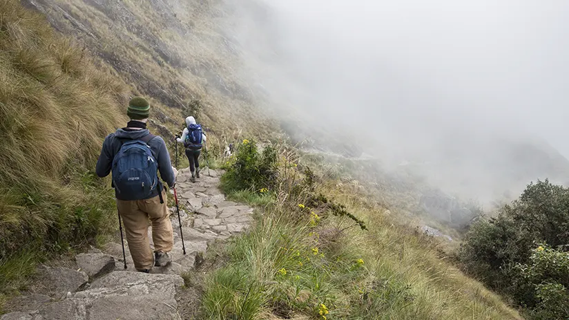
Travel Tips for Hiking in Peru

Proper planning makes hiking in Peru much easier. This matters even more on routes with high altitude, long distances, or changing weather. These tips also apply to Cusco travel tips, especially for travelers spending time in the region before a trek. Taking time to prepare well can make the entire experience safer, smoother, and more enjoyable.
- Give yourself time to acclimate: Spend at least a couple of days at altitude before starting a demanding trek.
- Consider a small group for more flexibility and a calmer pace on longer or more demanding routes.
- Start early when possible: Morning departures often bring clearer skies, cooler temperatures, and better trail conditions.
- Choose the right route for your level: Not every famous trail fits every traveler, so match the trek to your fitness and experience.
- Book permits and tours in advance: Popular routes like the Inca Trail often require early planning.
- Stay hydrated throughout the hike: Altitude, sun, and dry air can affect you faster than expected.
- Do not underestimate the weather: Cold mornings, strong sun, and sudden rain can all happen on the same route.
- Carry cash for small expenses: Some trailheads or local villages may not accept cards.
- Keep your pace steady: Moving too fast at altitude can make the hike much harder.
- Respect local communities and natural areas: Stay on marked paths and follow local guidance when passing through villages or protected areas.
- Listen to your body: If altitude symptoms or fatigue get worse, slowing down or stopping is always the smarter choice.
FAQs About Hiking in Peru
What are the best hikes in Peru?
The best hikes in Peru include the Inca Trail, Salkantay, Ausangate, Santa Cruz, Laguna 69, Rainbow Mountain, and Choquequirao. Each one offers a different experience, as some routes lead to Machu Picchu while others cross remote high-altitude trails in the Andes.
Do you need a guide for hiking in Peru?
You do not need a guide for every route in Peru, but some treks require one or are much easier with guided support. Travelers must book the Inca Trail with an authorized operator. Routes like Salkantay or Rainbow Mountain offer more flexibility. A local guide can also add safety, logistics support, and local context, especially on longer or higher-altitude routes.
What is the hardest trek in Peru?
Many hikers consider Huayhuash and Ausangate two of the hardest treks in Peru. Both combine long distances, high passes, and demanding altitude. These routes require strong physical preparation and suit hikers with previous trekking experience. Difficulty can also increase quickly without proper acclimatization.
When is the best time for hiking in Peru?
The best time for hiking in Peru is usually during the dry season, from May to September. These months often bring clearer skies, firmer trails, and better mountain views, especially on higher routes. June, July, and August are popular, while May and September often offer a better balance between good weather and fewer crowds.
How difficult is the Inca Trail?
Most travelers rate the Inca Trail as moderate to challenging. Altitude, stone steps, and the climb to Warmiwañusca Pass make it demanding. Many active hikers can complete it with proper preparation, but the route still requires stamina over several days. Time in Cusco before the trek can make the experience more manageable.
What should you pack for hiking in Peru?
You should pack layers, sun protection, good hiking shoes, water, snacks, and rain protection for hiking in Peru. On higher routes, cold mornings, strong sun, and sudden weather changes are all common. That is why flexible clothing matters more than heavy packing. For multi-day treks, it also helps to bring extra warm gear and any personal medication you may need.
“THE MOUNTAINS ARE CALLING, AND I MUST GO”
Hiking in Peru offers more than a physical challenge. It also brings travelers closer to the country’s landscapes, history, and mountain culture. Each route offers something different, from famous trails to quieter paths with fewer crowds. In the end, these experiences stay with you long after the hike is over.
Peru has so much to offer; it can be hard to know where to start. With many years of experience in the tourism sector, Machu Travel Peru is happy to help with anything regarding your trip to Peru and any tours around it. Let us help you make your Peruvian travel experience unforgettable! Contact us today to plan your dream adventure!