The Inca Trail to Machu Picchu is a trekking route famous worldwide because it is the same one that the Incas used to get to Machu Picchu, centuries ago. The ancient Incas route system called Qapac Ñam, covered all Tawantinsuyo territory from the South of Colombia, passing by Ecuador, Peru, Bolivia, Chile, and Argentina. The Inca Trail only occupies 26 miles of this large network and is a well-signed path that begins on km 82 of train rail leading to Machu Picchu, crossing high passes (13,780 feet), Sierra and jungle eyebrow. It is not recommended for the faint of heart, as the path can sometimes be very difficult.
As you already know, the Inca Trail to Machu Picchu requires a series of rules to be fulfilled.
Have your passport updated and not expired. When you process an Inca Trail permission through a travel agency, usually they require you a copy or scan of your passport. This is due to they have to complete your Inca Trail permission with your personal data. Therefore, your passport has to be up-to-date, in other words, your passport doesn’t have to be expired.
To hike the Classic Inca Trail to Machu Picchu, the tourist will have to start preparing before their departure. Take note that the Inca trail has slopes, unevenness, vertical descents, and precipices, so its journey will be a total adventure, and you will have to prepare 5 or 6 months in advance once booking an Inca trail experience.
In this form, you are going to prepare your body and mind for the real challenge.
The Inca Trail to Machu Picchu is by far the most famous trek in South America and is rated by many to be in the top five treks in the world. In its 26 miles (43 km) of travel, it manages to combine beautiful mountain scenery, lush cloud forest, subtropical jungle, and, of course, a stunning mix of Inca paving stones ruins, and tunnels. Regarding difficulty to hike. Happily, there are only two most importantly difficult to do on the Inca Trail.
Each camp zone has a latrine area where the passenger, ending the day, can use them. Of course, if you have a “Physiological need” or emergency during the day in the middle of a hike, all authorized travel agency has portable tent bathrooms. But, these one is only used in emergency real cases (take note that all solid waste has to be removed from the Inca trail to Machu Picchu).
For this reason, the latrines in the camp zones are the best option in case you will need to go to the bathroom. Regarding the showers, there are not exist along the Inca trail. Usually, the travel agencies implement a gallon of warm water with a tap and soap to wash the face and head in the mornings, before beginning the hiking and when getting to a camp zone, in the afternoons.
However, at an extra cost, some travel agencies can implement a portable shower tent, these are large water drums, previously heated, that let the water run through a pipe over the head of the user, but, as we tell you before, this means an expensive extra cost.
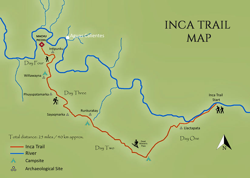
Usually, the traditional Inca Trail takes 4 days and 3 nights to be completed. The hike begins in the Km 82 of railways heading to Machu Picchu and finishes in the same citadel.
However, there is a shorter Inca Trail of 2 days and 1 night for those who want to enjoy, without any effort, beautiful landscapes, and the Incas marvel. The hike begins in the Km 104 of railways heading to Machu Picchu (this stop is closest to the citadel) and it takes 1 entire day to arrive at Mach Picchu. Of course, if you chose this route, you will have to spend a night in Aguas Calientes and depart to Cusco the next day.
If you have chosen the Inca Trail of 4 days and 3 nights, on the two first days you will walk around 6 to 9 hours per day. On the other hand, in the last two days, the time can be shortened by 2 hours. In the case of the Short Inca Trail to Machu Picchu (2D/1N), the day of the walk can take 7 hours to be completed.
The high point is the Dead Woman's Pass or Warmiwañusca, located on the second-day hike of the Inca Trail. This pass is over 7972 feet. If you climb up to this point, the following action will be going down the next day to get to Machu Picchu.
The Inca Trail is affected by the two well-defined seasons of Peru's sierra, too. The dry season (November to April) is considered the best time and the high season to do the hike because you will find warm and dry weather with clear skies, perfect for taking the best photos. Regarding the rainy season, it goes from May - October and presents hard rains, humid and cold weather and muddy paths, also slippery stairs, and mosquitos. So, take precautions.
As you could see, it all depends on the season. Of course, the coldest months are from November to April (the rainy season). The lower temperature can go from 32ºF to 41ºF. at nights, at the top of the Dead Woman Pass.
Remember that the Inca Trail to Machu Picchu is a hiking route. In this sense, you will need to wear:
These items will be useful for both seasons. However, if you plan to realize this activity during the rainy season, you will have to carry extra jackets and the second change of clothes.
No, the Inca Trail is closed in February to be maintained and refurbished. Remember that the Inca Trail route has wooden bridges, railings, and latrines in each camp, among others.
Travel agencies can schedule a guide for up to 16 people. That is, if you are the 17th traveler, you will have to go separately with another guide to complete another group or hike alone with this guide.
As we mentioned before, the availability of space in Camino Inca usually is sold out 6 or 7 months before. For this reason, reserving, through a travel agency once in Cusco is impossible, because, upon your arrival in the Imperial city, the spaces for the Inca Trail will be sold out. Always, book your Inca Trail permission through a travel agency and with 6 or 7 months before departing from your origin country to Peru.
A typical Inca Trail package includes the entrances to Inca Trail to Machu Picchu (These, in turn, include the entrance to the Inca citadel), a tour guide, transportation from your hotel to Ollantaytambo, touristic train services to km 82 or 104 (It depends on where your Inca Trail tour starts), cookers, porters (local people who help you to carry your backpacks, duffle bags inter alia. During the hike), food and camping equipment.
If you decide on the rent of tents, sleeping bags, mats, cane, and portable shower tents among others, you will have to pay an extra cost.
Having a large territory, the Tawantinsuyo, that covered the west of Colombia, all of Ecuador, all of Peru, southwest of Bolivia, north part of Chile, and the northwest of Argentina, the Incas required a well-connected network of paths to communicate, transmit, and share knowledge between towns, other cultures and the capital of the Empire, Cusco. In this form, the Qapac Ñam (the way of the mighty in the Quechua language) was born.
Therefore, the Inca Trail to Machu Picchu was created in the century XV, during the regency of the Inca Pachacutec, as a small stretch of the large Qhapaq Ñan, that linked Machu Picchu with Ollantaytambo, its exit to the Peruvian Sierra. The built of Inca Trail was made of a carved stone-like roadway. In the case of the flat, horizontal areas, free of vegetation and weeds, stone barriers were built on each side of the road. In the case of the coast, the pedestrian paths were built with the same earth of the zone, without using carved stone and without side barriers.
The American explorer Hiram Bingham discovered this stretch of Qapac Ñam in 1911, the same season that re-discovered the Incas citadel. (Remember that the true discoverer of Machu Picchu was a Cusco farmer named Agustin Lizarraga in 1902)
The name Qapac Ñam can be result difficult for those people who have other foreign languages than Quechua and want to name it. Therefore, the term "Inca Trail" or "route that was used by the Incas" is the most common and easy to name.
The Inca trail map shows a 50 km extension of the trekking route to get to Machu Picchu from the "82 km" point. This train stop is the halfway through the railway that connects Ollantaytambo with Machu Picchu. Also, the map shows camp zones, archeological sites, distances, high points, and tourist facilities. All this journey can be summarized in a 4-day trek. Therefore, any visitor who wants to do the complete Inca Trail route has to get off the train at this point (82 km).
As we mentioned, the Inca Trail begins at an 82 km point (Piscacucho town) and finishes in the same Machu Picchu Citadel. The trekking is considered moderate level. This is due to its location in the south of Peru, over slopes, steep valleys, ravines, and hills that are situated, in turn, northwest of Cusco. On the other side, what you can expect from day to day on the Inca Trail is a surprising set of emotions, challenges, and landscapes. For this reason, we will offer you a detailed Inca trail map and an idea of the road and the sites that you will see each day to enjoy the experience and plan your things to do in Machu Picchu to avoid any inconvenience.
The longest Inca Trail route (4-days), has points over 4200 meters above sea level. Therefore, acclimatizing the body beforehand will be important, to avoid the symptoms of the sea of Altitude. Also, the marvelous of the Inca Trail is that the route pass by Peruvian Sierra and Jungle. For this reason, you will feel dry and cold in Sierra and humid and warm Jungle weather. A radical temperature contrast enhances the experience of the Inca Trail. Also note that the Inca Trail to Machu Picchu presents two well-defined seasons, the dry season (from April to November) with clear skies and sunny days, and the rainy season (from December to March) with rains, cold weather, and muddy paths. Therefore, the Inca Trail route is closed in February of each year to avoid accidents and be refurbished.
Due to its location, the Inca Trail shares the same climatological characteristics as the Peruvian Sierra and jungle. In other words, the route presents two well-defined seasons during the year:
The rainy season (November - April): During these months the rains are frequent, with hail, thunder, lightning, and muddy roads. If you are a lover of adventure, this season can be for you. Only remember that the route is closed in February to avoid accidents and be reconditioned.
The dry season (May - October): The dry season is the best time to do the Inca Trail. This is mainly because there won’t be as much cloud and fog along the way, and you will be able to enjoy some of the most beautiful views the Inca Trail has to offer. With clear skies along the way, you will find breathtaking views and fantastic landscapes accompanied by numerous archaeological ruins.
In conclusion, if you are wondering What is the best time to hike the Inca Trail?, the answer is in the Dry Season, exactly, the months of June, July, and August. Clear skies, warm weather, perfect photos, and unforgettable remembers of your Inca Trail adventure.
The trail is accompanied by stunning views, unique flora and fauna, and several ancient Incan architectural sites. This wonderful trek ends by walking through the Sun Gate into Machu Picchu.
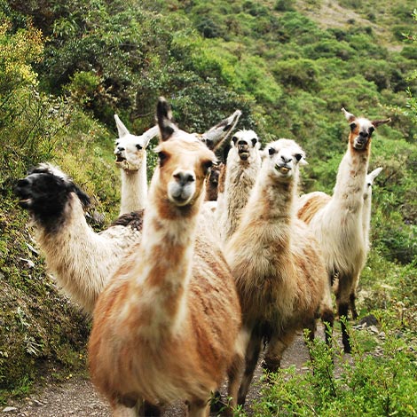
Acting as a bio-corridor between the Cusco Andes, the Sacred Valley, and the lowland Amazon forest, the historic sanctuary of Machu Picchu possesses over 370 birds, 47 mammal species, and over 700 butterfly species. Spectacled bears (Tremarctos Ornatus) and condors (Vultur Gryphus). But the best examples of fauna can be found in the Andean cougar (Puma Concolor), deer or Taruka (Hippocamelus Antisensis), cock-of-the-rock (Rupicola Peruviana), Churrete real (Cinclodes Aricomae), torrent duck (Merganetta Armata), Andean jergón (Bothrops andianus), Andean frog (Telmatobius), giant hummingbird (Patagona Gigas), a variety of butterflies and llamas.
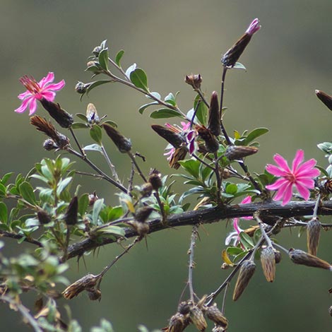
The variety of flora in the Inca Trail is awesome. Due to the fact of is located in the eyebrow Peruvian jungle, the Inca Trail to Machu Picchu hosts a great variety of high Andean grasses, and types of ichu like la Shulla, Chilla, and Crepilla. But, the treasure is located in the lower parts of the route, there is located typical vegetation of the place like ferns, alders, palm trees, puyas, and the famous Pisonay.
Other important types of vegetation are cedar, romerillo, intimpa, and laurel. Also, the Inca Trail route presents 400 species of orchids and begonias. On the other hand, the best examples of tree species are the Queuña, Pisonay, the Muña, and the Puyas.
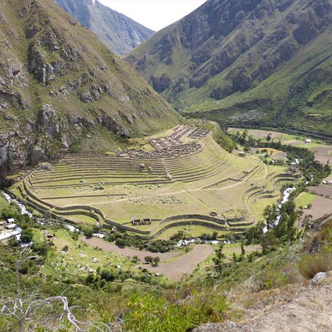
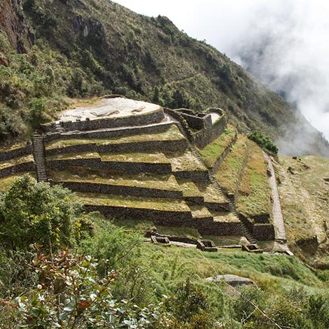
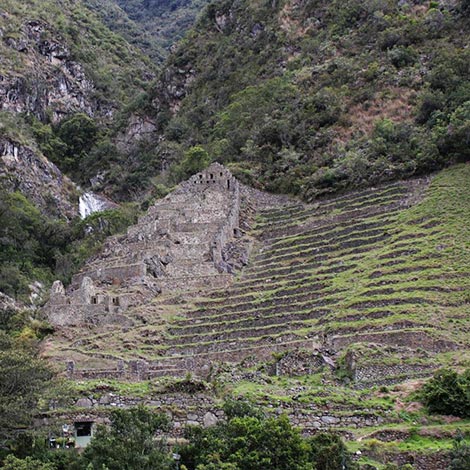
Llaqtapata, is located in the middle of the Kusichaca River and the Vilcanota River. This is a resting place surrounded by terraces that were used to produce crops during the Incan times.
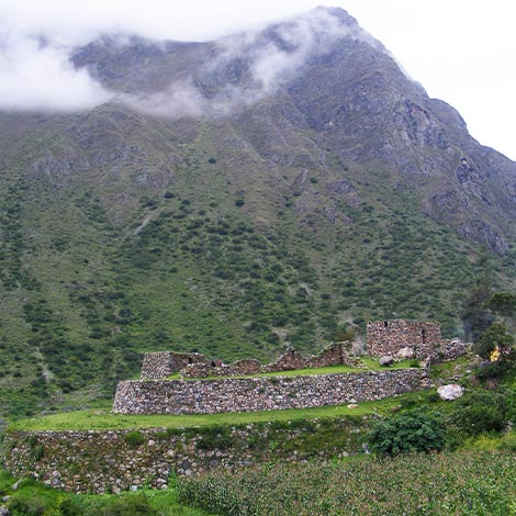
Wayllabamba or grassy plain (in the Quechua language) is the first llaqta (Inca's administrative center) that the visitors will find in the Inca Trail route. Besides being a little Inca citadel with the same name.
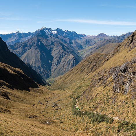
Warmi (woman) Wañusca (become dead) is the highest point at 4,215 meters (13,828 feet). You can admire an amazing panorama from this point.
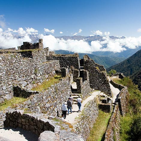
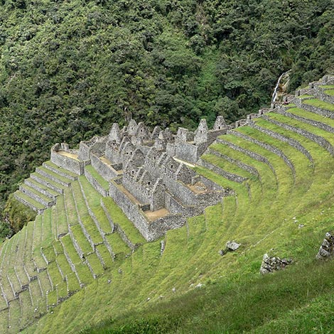
Runkurakay is an ancient Incan lodge with unique circular structures and precise stone masonry. It has remained in excellent condition over the centuries.
Sayacmarca, another Tambo (lodge) or checkpoint, in the same way as Machu Picchu.
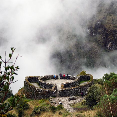
Phuyupatamarka, the place of the clouds. Like many Incan sites, this is no exception, it has achieved a remarkable balance between nature and the environment.
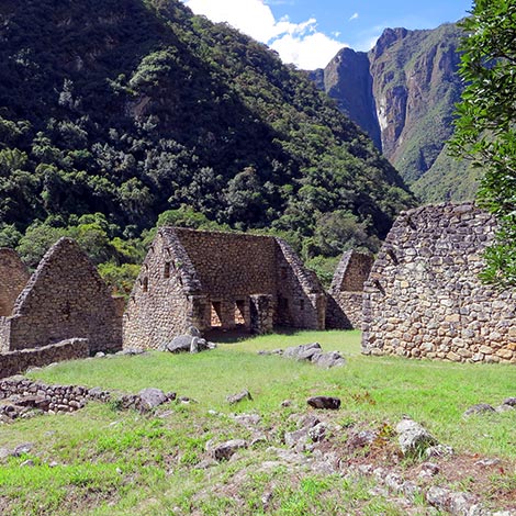
Chachabamba or Valley of mosquito bites is an Inca archaeological rest in a perfect state of conservation. This was a key location for surveillance and access control. The most relevant structures are the baths and water channels.
Choquesuysuy is an Inca archaeological site that is believed to have been dedicated to agriculture and vigil. The bases of circular structures are proof of this.
It's a very rough, two- or three-hour descent along a non-Inca track to the next ruin, a citadel almost as impressive as Machu Picchu, called Wiñay Wayna or "Forever Young". This is another place with fresh water, as well as the official Trekkers Hostal.
Consisting of only two major groups of architectural structures - a lower and an upper sector - Wiñay Wayna's most visible features are stone baths with apparently as many as nineteen springs feeding them, all set amid several layers of fine Inca terracing.
Nearby there's also a small waterfall created by streams coming down from the heights of Puyupatamarca. Much like today, it is believed that Wiñay Wayna was used by the Incas as a washing, cleansing, and resting point before arriving at the grand Machu Picchu citadel.
This is usually the spot for the last night of camping, and, especially in high season, the crowds mean that it's a good place to pitch your tent soon after lunch, but don't be surprised if someone pitches theirs right across your doorway, the area is small. To reach Machu Picchu for sunrise the next day you'll have to get up very early with a torch to avoid the rush and the crowds.
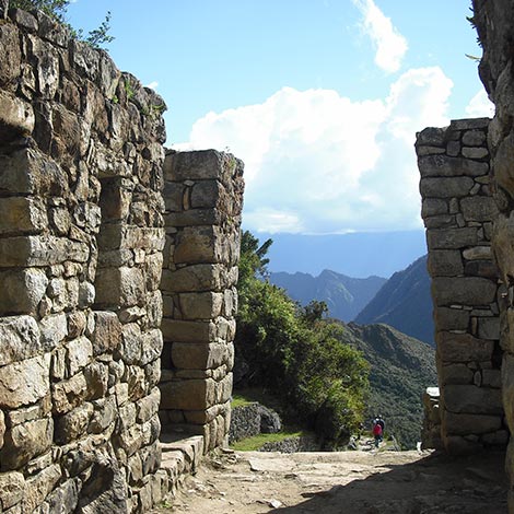
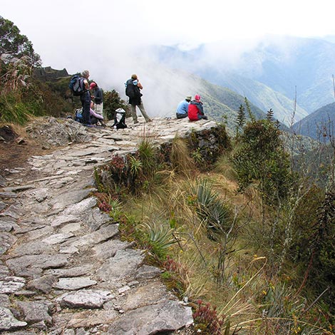
A well-marked track from Wiñay Wayna takes a right fork for about two more hours through sumptuous vegetated slopes to the stone archway entrance called Intipunku (Gateway of the Sun), from where you get your first sight of Machu Picchu - a stupendous moment, however, exhausted you might be. Aim to get to Machu Picchu well before 9.30 am, when the first hordes arrive off the train from Cusco, if possible.
Cusco was the ancient capital of the Incas and is the current capital of the region of the same name. There are the main transport ports that connect the Andean city with the rest of the Peruvian cities, including Lima.
For those who want to hike the short Inca Trail (2D/1N) from km 104, he will need to follow the same steps. First, take a train directly from Cusco to km 104 (passing by Ollantaytambo) Or, take transportation from Cusco to Ollantaytambo and from there take a train to km 104. Following, get off in km 104 (Previously showing train stop authorization). And from this point, to begin the hike to the Inca Trail.
Before beginning the Inca Trail, we always recommend taking a few days in the beautiful Imperial City to acclimatize the body to the altitude. Keep in mind that one of the things that we will have to face in our ascent will be the height, so acclimatization in Cusco is almost mandatory. The hike itself begins in a wonderful place called Kilometer 82. As its name indicates, this trail is 82 kilometers along the railway from Cusco to Machu Picchu. The Inca Trail is only one way to the citadel, so will be better to take a comfortable train ride on your way back to Cusco. This is the traditional Inca Trail route and is formed by 4 days and 3 nights.
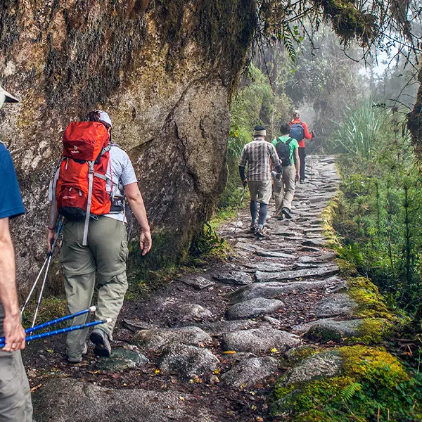
Usually, on the first day, you will go by bus from Cusco to Ollantaytambo. And from it to Km 82, also called Piscacucho, where the hikers’ route begins. The first section is quite easy, a level and horizontal path of 5 hours of trek, so it is advisable to save your strength as it will become more difficult later with a climb stretch. You will stop at Q’oriwayrachina for lunch before crossing the Urubamba River at Q’ente. Next, you will have an option to visit the archaeological sites of Wayna Q’ente and Llaqtapata. From there, you will head to a small town from which you can see the first archaeological ruin called Huillca Raccay. A few kilometers later you will arrive at Wayllabamba where you will rest for the night. First camp.
(Time: 5-6 hours, Distance: 11 km).
The second day is when the fun begins, it is one of the most difficult parts of the Inca Trail to Machu Picchu, due to its inclination. After a few kilometers of going straight through the slopes of Cusichaca Valley, you will begin to notice that the trail begins to steep up to the Andean community of Huayllabamba gradually. From there, you have another 2 hours to climb up to Warmiwañuska (the Dead Woman Pass in the Quechua language) Here, we will have a breathtaking view of Mt. Huayanay. After reaching the top and taking all the necessary photos, you will have about 2 more kilometers to the camp. As the trail descends along this narrow valley, we will begin to see cloud forest flora that harbors the queñua tree (polilepis) Your camp will be set up at Llulluchapampa, where you will rest for the night.
(Time: 6 hours. Distance: 9 km).
After waking up, you will go up, slowly, to other beautiful ruins of Runkuraqay and the second pass at 4,050 m (13,200 ft). From there, you can see mostly paved Inca trails and staircases that descend to a little gully. Next, we walk down to the site at Sayacmarca, 3,850 m (12,551 ft), on the original Inca Trail, passing a dry lake where you will appreciate the beginnings of a cloud forest. In a beautiful location overlooking the Aobamba Valley, we will have time for a leisurely walk through its imposing structures. We then continue along the ridge, viewing Mt. Salkantay and Mt. Pumasillo, a silhouette on the northern horizon. So be prepared to go downhill for a while. This third-day hike usually takes 6 to 8 hours, giving you plenty of time to take photos and observe the beautiful sightings. You have to be alert, take advantage, and ask your guide about the different ruins on the Inca Trail map. Finally, you will arrive at one of the last places to camp and rest, called Wiñay Wayna. Third camp.
(Trekking: 7-8 hours, Distance: 14 km).
The last day of the Inca Trail to Machu Picchu is one of the unique days of the trail. All the effort of the hike sees its fruition when you arrive at Machu Picchu. From Wiñay Wayna, you will trek to the Sun Gate in Machu Picchu or Inti Punku. Once you get there, you will be presented with a unique view of your goal, Machu Picchu. The final triumphal descent to the citadel takes about one hour more. You will find out how this route is one of the best adventure holidays in Peru.
(Trekking: 3-4 hours, Distance: 7 km).
For those people who don’t have a good physical condition or didn’t have time to prepare themselves for the challenge that the Inca Trail hiking represents, there is the shortest and easiest route. The Inca Trail of 2 days and 1 night. To do this hike, you have to follow the same steps as if you were taking the full Inca Trail. In other words, take the train from Cusco or Ollantaytambo heading to Machu Picchu. The only difference is that instead of getting off in kilometer 82, you have to get off in kilometer 104 (closest to the citadel).
From this point will begin the adventure. First, you will visit the Chachabamba archaeological rest (7382 feet), where you’ll see beautiful landscapes and unique flora surrounding the zone, besides appreciating the archaeological place of the same name. Following, you’ll begin to climb up a mountain for around 2 and half hours heading to Wiñay Wayna (8694 feet), another amazing Inca archaeological rest, with Andean terraces and little rooms made of stone blocks (Possibly they served as food stores or Tambos). There, usually, the tourist enjoys a Picnic lunch managed by his travel agency. In additional info, Wiñay Wayna is the third camp where other tourists (who make the complete Inca Trail hiking) rest, arrive and depart. After the picnic lunch, in the afternoon, the hike follows up to get to the Sun Gate or Inti Punku, where you’ll have the best pictures of Machu Picchu. Next, the descent to the citadel begins. The advantage of taking this hike is the possibility of finding Machu Picchu mountain and the citadel, in those afternoon hours, almost empty. Finally, after visiting the citadel, you will take a bus to go down to Aguas Calientes town, where you will spend the night.
(Time: 6 hours, Distance: 09 km).
The next day, from Aguas Calientes, take a train returning to Cusco, directly or to Ollantaytambo town, from there, you will have to take transportation to lead to Cusco.
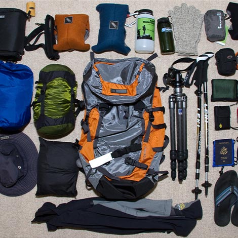
During the route, approximately five kilos are allocated to you for your items. But, don’t worry, the Peruvian porters will carry it for you, so keep in mind that you will need to bring only the essentials in your bag. You will generally be given a duffle bag by your travel agency, which the porters carry as well. So think carefully when you are packing for the Inca Trail. Some people bring their blankets from home and their sheets to put inside their sleeping bags. Big mistake!
We can start by saying that making the Inca Trail to Machu Picchu by yourself is completely forbidden. The permission, the operation, and the logistics have to be in charge of an authorized local travel agency (It is due to Peruvian government regulation) For this reason, if you are caught doing the Inca Trail on your own, without a guide company or the support of an agency, you can be arrested by the park rangers. In other words, you will always have to hire the services of an authorized local tour operator.
But, How much does the Inca Trail cost? You will find that among the different tour companies or travel agencies, the Inca Trail cost does not drop below US$ 600 per person. And this is the price of the basic coverage of the trek. This includes transportation from the lodging to the starting point of the trek, porters, guides, three meals a day, the Machu Picchu entrance ticket, and the same tents where you will rest.
In general, the most reliable local operators offer the service at a relatively medium price. From these companies, you can expect an Inca Trail cost that ranges between $ 700 and $ 900 per person. This service involves joining a group that can consist of up to 12 hikers. As with the basic service, you can wait for transportation and pick up from your hotel until the start of the trek. It also includes what are the tickets for Machu Picchu, porters, bilingual guides, camping equipment, trekking equipment, and three meals a day. Besides, the service includes both the shuttle bus tickets to Aguas Calientes and the return trip by train to Cusco. Although it is also important to verify what is included and what is not.
Now, if you are looking for other types of amenities or included services, the price will obviously go up. For example, at the higher end of the spectrum, the most complete services may be in the $ 1,500 range. This price difference will be reflected in the quality of the service and what it includes.
In some clandestine (illegal) companies, you may find a lower price, but with inefficient services, like groups of more than 25 people, with little food, and no snacks. In this form, Many of these companies improvise as they hike and make your Inca Trail experience a forgettable one but remember that it is best to guide us by their reputation. In tourism, you get what you pay for. It is best to choose a company that has a certain reputation to offer this amazing hike.
The Peruvian government has decided to make some regulations regarding the entrance of the Inca Trail to Machu Picchu. Therefore, only about 500 people are allowed to enter per day. And of those 500 places, about 300 of them are reserved for porters, guides, and other staff. Therefore, the booking for the Inca Trail must be made well in advance, as it is a highly demanded route. Also, the Peruvian Government, through the Culture Ministry (park management institution) establishes that no visitor or tourist can do the Inca Trail on their own. All hikers have to be accompanied (with authorized tour guides), operated, and supported by a local (Cusco) tour operator. Therefore, the entrance and permission of the Inca Trail are only sold through these authorized local tour operators.
But before making a reservation for the Inca Trail, we recommend taking these tips into account:
You have to make sure that your passport is valid for at least 6 months after the date of your entry to Peru. Without your passport information, the local tour operators have no way of booking the Inca Trail. So if you plan to contact any local (Cusco) travel agency and make Machu Picchu reservations from the comfort of your home, first make sure that your passport is valid. The information that is in the passport will be the one that will be presented on your travel permit. Once the ticket is purchased, the data presented cannot be switched. The departure date cannot be changed either, so you must be well organized.
Before starting the route, your passport details will be verified with that of your provided ticket. In case you decide to renew your passport, you will have to notify it. Especially once the purchase is settled. And only the passport number can be updated in case of renewal. This can only be done one week before the departure date. You will need to send a copy of both passports, the old one and the new one. And in addition, a fee for changes of $10 will be applied
Before embarking on your trip, it is vital to be able to verify your permits with the local travel agency. It is advisable to check the information on your package and what it offers. If you are looking for a special service or some kind of comfort, it is advisable to specify it before booking for the Inca Trail. Once the reservation is made, you will not be able to specify your details. But, where can I book the Inca Trail? In any local tour operator of Cusco. You can make reservations from the comfort of your home. Doing it online, and making contact with your travel agency, is usually the most common way to do it.
Have you ever wondered: How do I book an Inca Trail ticket? Well, it is something quite simple. Once you have your passport in order, your dates ready, and the motivation to undertake this adventure, you will be ready. To make the booking for the Inca Trail, you must choose some of the hundreds of local (Cusco) certified operators to provide this service. Keep in mind that it is impossible to get these tickets on your own. First of all, the presence of guides and porters is mandatory to enjoy a unique experience. In addition, the experience is undertaken in organized groups.
So if you travel as a family, this route is an excellent option for your vacations. Once you have chosen a trusted operator or agency, you can start to inquire about their available packages. You can decide whether to choose your dates or form your own group in case you travel with your family. If you find yourself alone, don’t worry, the operators will take care of adding you to another group. As long as you make your booking for the Inca Trail a few months in advance, you don’t have to worry about anything.
To enjoy the Inca Trail experience and its route, you have to make a previous deposit to the local tour operator of your choice. This is essential in order to proceed with the permit purchase process. You can make the payment with credit cards such as American Express, MasterCard, Visa, and Discover among others. Depending on the company, operator, or agency you choose, you can pay in other ways. You can choose between deposits, transfers, or other online payment methods.
Another important thing to consider is that tickets are sold on a first-come, first-served basis. In certain cases, you may see that there are still permits available to buy. But in unlikely cases, it may happen that these tickets have sold out quickly. And in case you cannot make your trip on another available date, the local tour operator is authorized to refund your deposit. But once the Peruvian government has issued and confirmed the ticket, the deposit becomes non-refundable.
It's important to make time to acclimatize to the altitude before tackling the Inca Trail or any other high Andean trek, especially if you've flown straight up from sea level to a city of height, like Cusco (Starting point for anyone who wants to do the Inca Trail).
Most people select a tour to suit them from among the multitude of agencies registered for the Inca Trail; the company will take care of everything including your registration, entrances, and permissions for the Inca Trail. However, the demand is so great that it is essential to book at least nine months in advance and make your booking deposit.
Choose your season for hiking the Inca Trail carefully. June, July, and August are the best month to venture on a hike here, with clear views, fine weather, and verdant surroundings. Locals will tell you that the best time to hike is during a full moon, and it certainly has a more romantic, even mystical feeling during your journey.
There are only 500 hikers allowed on the trail every day. The permits can sell out up to 5 months in advance, especially for the dry season.
It is important to book Inca trail tickets months in advance.
The Inca Trail is closed in February of every year for maintenance and refurbishment.
All carrier animals, like llamas, horses, and donkeys, are banned from the Inca Trail. Instead, porters are hired and take care of most of the supplies. Also, extra porters can be hired to carry personal items like backpacks, and duffle bags among others.
Private porters are able to carry from 8 kg to 15 kg. But you also have to remember that 2.5 kg has to be set aside for a pad and sleeping bag.
It is a requirement for walking the Inca Trail. Travel insurance will protect you against injury, illness, cancellations, and more. But make sure it also covers you for activities at altitude.
- Fitness condition: The Inca Trail is an incredible experience of a lifetime, but not an easy trek. So, having a good level of physical fitness makes everything more pleasant. We recommend you do some cardio to increase your endurance. Also, pack light and smart to carry just the necessary.
- Calories: We highly recommend you take some high-calorie snacks, such as seeds and nuts, to keep your energy, because you will burn a lot of calories during the trek.
- Stay hydrated: During the four-day hike, you will do an intense physical effort, so you must drink enough water each day. Salt tablets can help you as well.
- Mental preparation: Go slow and do not push yourself. Try to consider this challenging trek as a motivating adventure and take your time to enjoy it.