The scattered population of the region is descended from two very ancient Andean ethnic groups or tribes – the Aymara and the Quechua. The aymara´s Tiahuanaco culture predates the Quechua´s Inca civilization by over three hundred years and this region is thought to be the original home for the domestication of a number of very important plants, not least the potato, tomato and the common pepper.
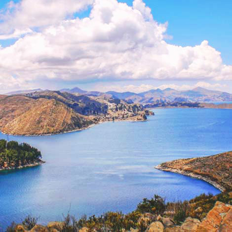 Lake Titicaca is the border that separates Peru from Bolivia, the lake spreads over the Altiplano with 3,200 square miles, it has a height of 12,500ft above sea level, which makes it the highest lake in the world to navigate.
Puno borders the Peruvian side of the lake.
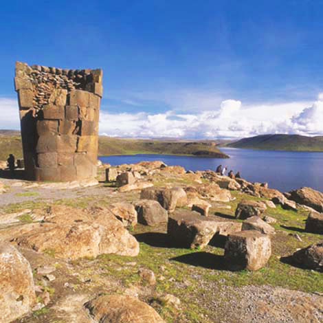
Scattered all around Lake Titicaca you´ll find chullpas, gargantuan white-stone towers up to 10 m in height in which the ancient Colla tribe, who dominated the region before the Incas, buried their dead. Some of the most spectacular are at SILLUSTANI, set on a little peninsula in Lake Umayo overlooking Titicaca, 30 km northwest of Puno. This ancient temple/cemetery consists of a ring of stones more than five hundred years old – some of which have been tumbled by earthquakes or, more recently, by tomb robbers intent on stealing the rich goods (ceramics, jewelry and a few weapons) buried with important mummies. Two styles predominate at this site: the honeycomb chullpas and those whose superb stonework was influenced by the advance of the Inca Empire. The former is set aside from the rest and characterized by large stone slabs around a central core; some of them are carved, but most are simply plastered with white mud and small stones. The later, Inca-type stonework is more complicated and in some cases, you can see the elaborate corner-jointing typical of Cusco masonry.
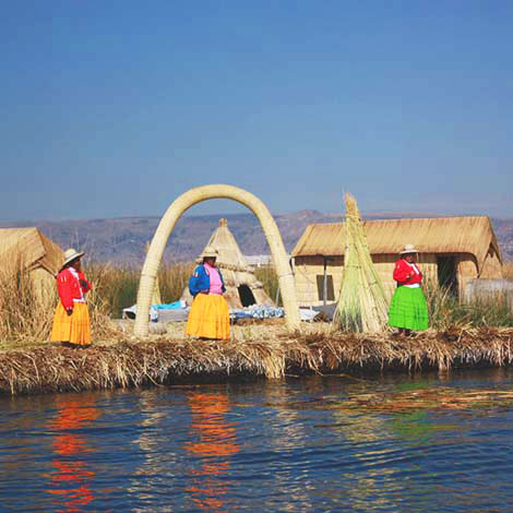
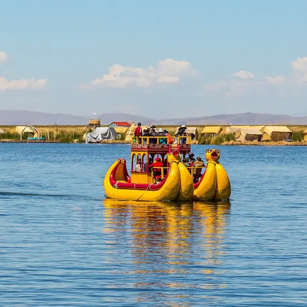
The man-made floating UROS ISLANDS have been inhabited since their construction centuries ago by Uros Indians retreating from more powerful neighbors like the Incas. They are now home to a dwindling and much-abused Indian population. Although there are about 48 of these islands, most guided tours limit themselves to the largest, Huacavacani, where several families live alongside a floating Seventh-Day Adventist missionary school.
The islands are made from layer upon layer of totora reeds, the dominant plant in the shallows of Titicaca and a source of food (the inner juicy bits near the roots), as well as the basic material for roofing, walling and fishing rafts. During the rainy season months of November to February, it´s not unusual for some of the islands to move about the surface of the lake.
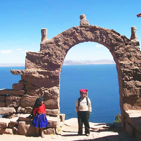
One of Titicaca´s non-floating islands, TAQUILE is peaceful place that sees fewer tourists than the Uros. Located 25-30 km across the water from Puno it lies just beyond the outer edge of the Gulf of Chucuito. Taquile is arguably the mots attractive of the islands hereabouts, measuring about 1 km by 7 km, and looking from some angles like a huge ribbed whale, large and bulbous to the east, tapering to its western tail end. The horizontal striations are produced by significant amounts of ancient terracing along the steep-sided shores. Such terraces are at an even greater premium here in the middle of the lake where soil erosion would otherwise slowly kill the island´s largely self-sufficient agricultural economy, of which potatoes, corn, broad beans and hardy quinoa are the main crops. Without good soil Taquile could become like the main floating islands, depending almost exclusively on tourism for its income. Today, the island is still very traditional. There is no grid-connected electricity on the island, though there is a solar-powered community loudspeaker and a growing number of individual houses with solar lighting; it´s therefore a good idea to take o torch, matches, and candles.
The island has two main ports: Puerto Chilcano Doc (on the west of the Puno side of the island) and El Otro Puerto (on the north side, used mostly by tour boats of tour agents because it has an easier and equally panoramic access climb). Arriving via Puerto Chilcano Doc, the main heart of the island is reached via 525 grueling steps up a steep hill from the small stone harbor; this can easily take an hour of slow walking. When you´ve recovered your breath, you will eventually appreciate the spectacular view of the southeast of the island where you can see the hilltop ruins of Uray K´ari, built of stone in the Tiahuanaco era around 800 AD; looking to the west you may glimpse the larger, slightly higher ruins of Hanan K´ari. On arrival before climbing the stairs, you´ll be met by a committee of locals who delegate various native families to look after particular travelers – be aware that your family may live in basic conditions and speak no Spanish, let alone English (Quechua being the first language).
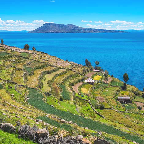
Like nearby Taquile, AMANTANI, a basketweavers island and the largest on the lake, has managed to retain some degree of cultural isolation and autonomous control over the tourist trade. Amantani is the least visited of these two islands and consequently has fewer facilities and costs slightly more to reach by boar. Of course, tourism has had its effect on the local population, so it´s not uncommon to be offered drinks, then charged later, or for the children to sing you songs without being asked, expecting to be paid. The ancient agricultural terraces are excellently maintained, and traditional stone masonry is still practiced, as are the old Inca systems of agriculture, labor and ritual trade. The islanders eat mainly vegetables, with meat and fruit being rare commodities, and the women dress in colorful clothes, very distinctly woven. The island is dominated by two small hills: one is the Temple of Pachamama (Mother Earth) and the other the Temple of Pachatata (Father Earth). Around February 20, the islanders celebrate their main festival with half the 5000-strong population going to one hill, the other half gathering at the other. Following ancient ceremonies, the two halves then gather together to celebrate their origins with traditional and colorful music and dance.
Before there was any sort of division in the lake, separating Peru and Bolivia, ancient civilizations establishes themselves in the region. During some years the communities were able to live together peacefully, but some periods are tainted by war. Agriculture and building methods have been adapted and improved over the years, the Andean religious beliefs have also been tinkered with to adapt the new catholic concepts. All the cultural differences are what make the Lake Titicaca community and culture so unique and interesting. Seeing similarities between the islands is a fun learning experience, for example the clothing worn on each island has a different symbolism. A man on the Taquile island will show his marital status by the color of the hat on his head, not buy a ring on his finger. Make sure to pay close attention to your guide while touring the islands, you are likely to hear other native languages like Quechua and Aymara.
The best way to show appreciation for a job well done is to reflect it in a tip. Here we have a tipping range for your guide, depending if it’s a full or half day.
*The amount of money also varies with hoe many people are in the group, the amount can be divided among everyone. Also remember that the amount you leave is completely up to you.
Jump on board on one of our boats with an expert guide and explore the nearby floating islands, the reed islands of Uros is a great place to visit and the Taquile island (famous for its textile traditions) is only a short boat ride away. You can learn about traditions that are centuries old by the people that actually live on the islands. If one day is not enough, there are over night options, stay the night with a host family and visit Uros, Taquile and Amantani.
If you are looking for a unique experience on the islands and want to learn about the local’s everyday life, then consider staying the night with a resident family. Appreciate their stories and enjoy a home cooked meal made with the freshest ingredients, which are locally grown. During the day tours experience a local party with music and dancing where you be dressed in traditional gear. The homestay housing can be very fun but also very modest, don’t expect running water or electricity.
Planning a vacation to an island in the middle of a lake may seem a little odd, but the Suasi Island can provide a very luxurious getaway, in an extremely quiet area with the best features. With activities like hiking and exploring the island during the day, unwind and relax with a massage, and finish the day with cocktails while watching the sun set.
The best way to get to know this amazing lake is buy sailing on a traditional, handmade, torta reed boat, kayaks are also available for renting. For those who are feeling courageous can take a dip in the freezing 50-57’F (10-14’C) water. For those who prefer land, there are hikes on Isla del Sol (Bolivia), Taqulie and Amantani islands (Peru). While there you can also visit some local lamas.
The Amazon has a warm, tropical climate with high humidity. Average temperatures range from 25°C (77° F) to 42°C (107°F).
May through October are usually the driest months in the Amazon. Between June to September, there are periodic cold spells called friajes that can drop the temperature to 10°C (50°F) for a couple days at a time. Friajes are cold fronts the blow up from Patagonia and then whip down over the southern jungle from the Andes.
The Amazon is a rainforest, so really there’s chance of rain throughout the year. But more constant rains that define the region’s wet season begin in November and continue to April. November and December usually receive the most rainfall.