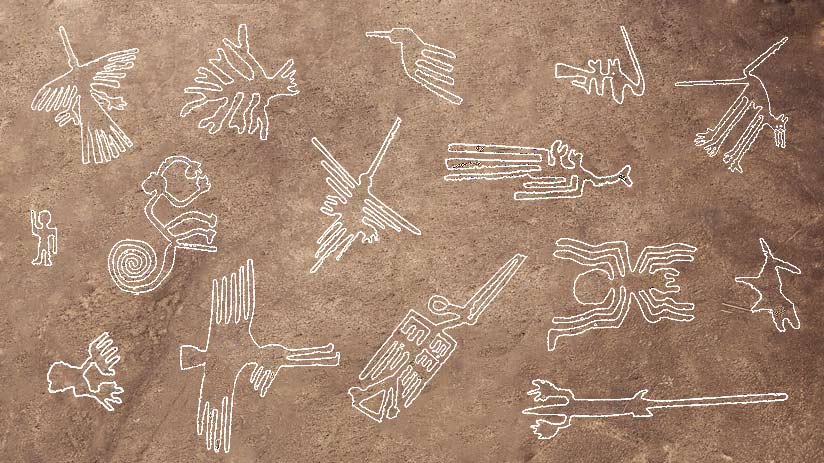
The renowned Nazca lines images are a group of more than 300 giant and indecipherable geoglyphs of plants, animals, and humanoids graphed between the years 1 and 600 AD by the Nazca pre-Inca culture in the middle of the south Peruvian desert. Nazca region, south of Lima, the capital of Peru. Precisely, the engravings of animals are the ones that attract the most attention. Therefore, together with the experts at Machu Travel Peru, we would like to tell you a little about the best Nazca lines images. A mystery that still leaves the world intrigued.
Watch the video below to explore one of the most fascinating archaeological mysteries in the world: the Nazca Lines of southern Peru. This visual journey shows aerial views of the geoglyphs, highlights their scale and artistry, and introduces key theories about why these massive designs were created.
The most important Nazca lines images to appreciate
The Nazca Lines images
Who engraved them and their main purpose have been the subject of debate among archaeologists and scientists for years, giving rise to numerous theories. Some of these hypotheses are more accepted by scientists, while others delve into impossible-to-test theoretical scenarios. Even, some groups of scholars suggest that these were done by two different pre-Incas cultures and in separate periods, they refer to Paracas (700 BC – 200 AC) and Nazca cultures (1 – 600 BC). The lines take the name of their last designers.
The different Nazca line figures vary greatly in size, shape, and complexity. These were formed by digging the reddish and rusty soil of the place to reach a depth of 30 to 40 cm, discovering a lighter and yellowish layer of dust. In turn, the width of each line can vary from 40 to 210 centimeters. Also, it is possible to distinguish 2 figure styles, the biggest are those with animal forms with a size of up to 400 square miles. It is believed that those were used as worship zones (Nazca ceramic rest were found close to them). The second one are smaller, represents humanoid figures, and can be extended from 15 to 365 meters. These are located close to ancient paths, for this reason, it is believed that were used as references and location points.
1. The Condor
The condor geoglyph is one of the most famous and recognizable Nazca lines images. But lately, some expert groups suggest that this figure looks much more like that of a Chaucato (a long-tailed nightingale). Precisely this bird tends to hover very close to the lines, making this theory probable. While the Andean condors can be seen more than 100 miles from the area (In the Peru Andes). Although it would not be surprising to see the representation of an animal foreign to the area. Since as can be seen in other figures, there are geoglyphs of animals characteristic of other areas and zones.
Similarly, the condor geoglyph is one of the largest and most surprising, reaching 130 meters long and 115 meters wide. The images and words do not do justice to these ancient wonders, so we recommend that you see them with your own eyes. Being in front of them, you will begin to wonder how were the Nazca lines made.
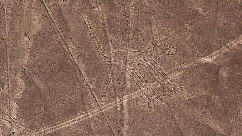
2. The Monkey
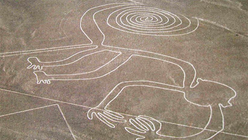
The Nazca Monkey is a large geoglyph, measuring about 330 feet long and about 190 feet high. Among the different geoglyphs, the monkey is one of the most iconic, emblematic, and fun Nazca lines images. This monkey’s geoglyph is represented by only nine fingers and a spiral-shaped tail and is another of the representations of Peruvian Amazon fauna since it represents an animal not very characteristic of the Nazca desert region. Although monkeys are clear Peruvian jungle inhabitants (zone located far away from the Peruvian desserts), their presence there may suggest some trade routes established during the rise of the Nazca culture.
Its mere representation shows the great knowledge of the Nazca civilization about the fauna of entire Peru. Consequently, within a Nazca lines tour, you will be able to appreciate this figure along with many others, being able to contemplate the titanic task of this ancient civilization.
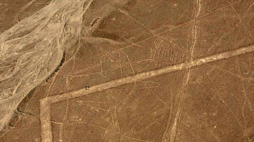
3. The Astronaut
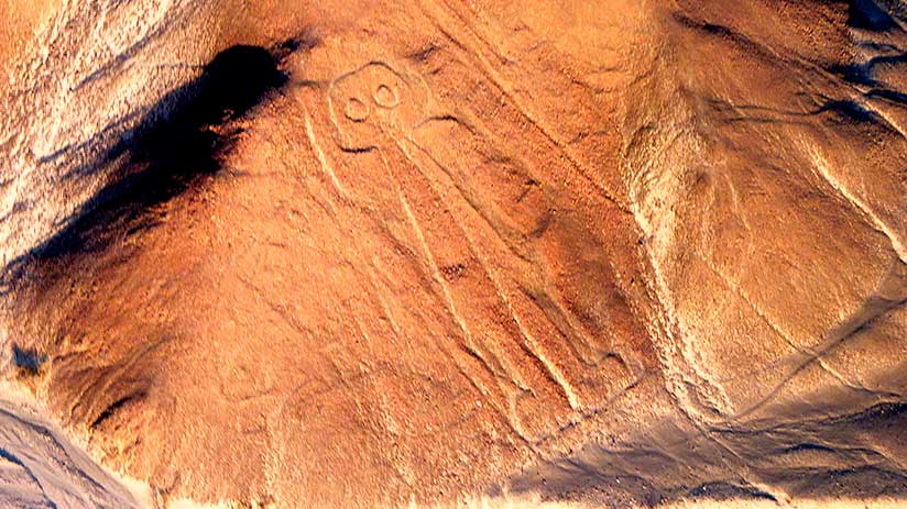
Almost all Nazca lines drawings are faithful representations of some key animals in the Nazca culture. But there are also some images or figures that are a complete mystery and this one is a clear example. Nicknamed the astronaut, the giant, or the owl-man, this geoglyph leaves many puzzled and causes numerous outlandish theories about its form, use, and meaning. Moreover, some researchers even believe that it is an image much older than the Nazca culture, belonging to the Paracas culture. Precisely, this image appears to be the figure of a human being with large eyes y boots on the feet.
Even, some argue that it may be a type of fisherman due to can be seen holding a net in his left hand, which is more logical due to the proximity of the area to the sea. In any case, today, this humanoid figure remains an enigma for many academics. Therefore, if you want to better appreciate the image of the astronaut, you have to fly over Nazca lines.
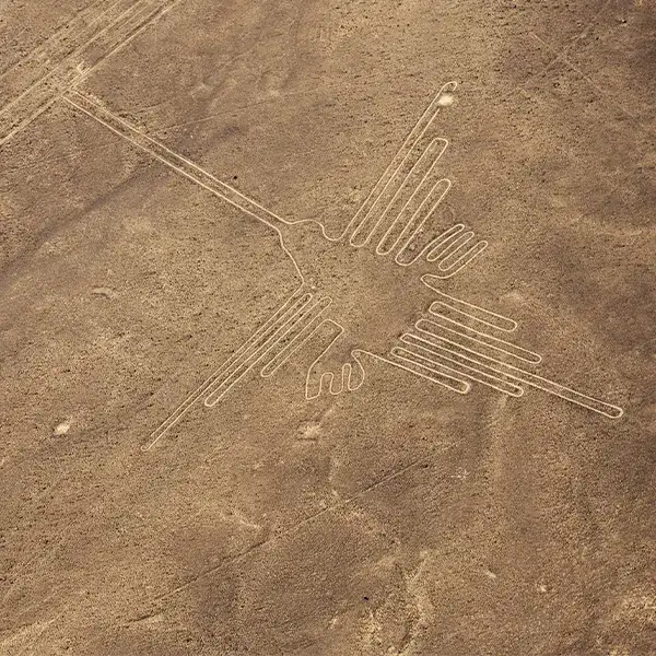
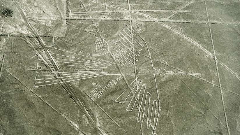
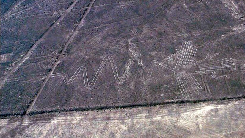
4. The Hummingbird
Undoubtedly, when one does the Nazca Lines tour, the hummingbird is one of these figures that has been represented more times in articles, studies, and even photography collections. Not in vain, Peru is home to many species of hummingbirds, with more than 125 registered species. For this reason, Maria Rostorowski, an important Peruvian historian, affirmed that the hummingbird was an important deity or flying god, respected and feared by the Nazca population. So much so that they offered offerings annually so that God Hummingbirds did not punish them with drought and lack of rain.
This figure that attracts so much attention has an excellent layout, so much so that you can spot it without difficulties in your flight over the lines. The measurement of its well-deployed wings and its pointed peak reaches an extension of 97 meters. This incredible Nazca line image is an amazing 320 feet long and 216 feet wide. A giant representation of such a small animal if you think about it.
5. The Parrot
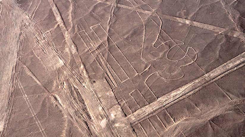
The Parrot is not so easy to spot, as there are hundreds of other lines traversing the area. But if you have a good eye, you will be able to at least make out its beak and head along with a large crest that protrudes from one side. The majority of these forms are circles and show us the uniqueness of its style. Unfortunately, the lower part of its image has been altered due to continuous erosion and human manipulation (over there, some paths and roads were built). Despite this, you can still see its wings which are curiously represented by two parallel rectangular shapes, which demonstrates that its representation and design are somewhat unnatural. Unleashing the imagination of numerous theorists and academics who are drawn to the figure, and have shaped many Nazca lines theories.
6. The Spider
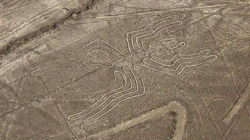
While all the Nazca lines drawings are amazing, the spider is one of the most distinguishable figures from the sky. This was one of the first geoglyphs sighted by Paul Kosok, one of the first serious scholars to study the lines. The Nazca spider is about 150 feet long and quite large, it is even very well-defined making it very easy to find it within the Nazca lines map. This figure is part of a network of lines located on the edge of a trapezoid, and it is believed had religious and astronomical purposes.
The spider is an outstanding figure thanks to its characteristic line. Since the width of the drawn lines fluctuates between 210 centimeters in their widest areas. While in its less wide areas the lines reach about 40 centimeters. One of the best figures to appreciate on your next tour.
7. The Whale
It is not surprising that this ancient culture decided to revere this majestic animal, standing very close to the coasts. Among the different Nazca lines pictures, the whale has a fairly simple but easily recognizable design. Also, Nazca culture decided to symbolize a great variety of indigenous animals painted previously in its ceramics to capture them on the great canvas of the Peruvian desert. In fact, there is a second whale geoglyph that resembles an Orca or Killer Whale. This has a much more complicated design and it’s really difficult to distinguish. Undoubtedly, these animals are one of the best examples of the variety appreciated in the Nazca lines.
8. The Dog
Believe it or not, the Nazca Lines images feature the not-so-known representation of a dog! That’s right, a geoglyph of a dog! The Nazca dog appears to be in a startled and alert state. In the representation, you can distinguish the upright posture of the dog with limbs and tail stretched out straight, ears pointed, and eyes and mouth open. Although it may just be stretching. The dog geoglyph has dimensions that do not exceed 170 feet in length. It is believed that this representation refers to the characteristic Peruvian dog, known as the Peruvian Inca Orchid. It is one of the native races of Peru, which does not have hair.
9. The Pelican
There are some Nazca Lines Images that are truly difficult to distinguish and discern. Especially when it comes to the Pelican, also known as Alcatraz, an old Spanish name for Pelican. Although this geoglyph is also known as Flamenco, Cormorant, or even a Phoenix. Its representation is that of a winged body with a long neck in the shape of a zig-zag. The figure ends with a head and narrow spikes that can measure up to 935 feet long, one of the longest geoglyphs in all of Nazca. In this sense, locating it is very easy!
New Nazca lines images
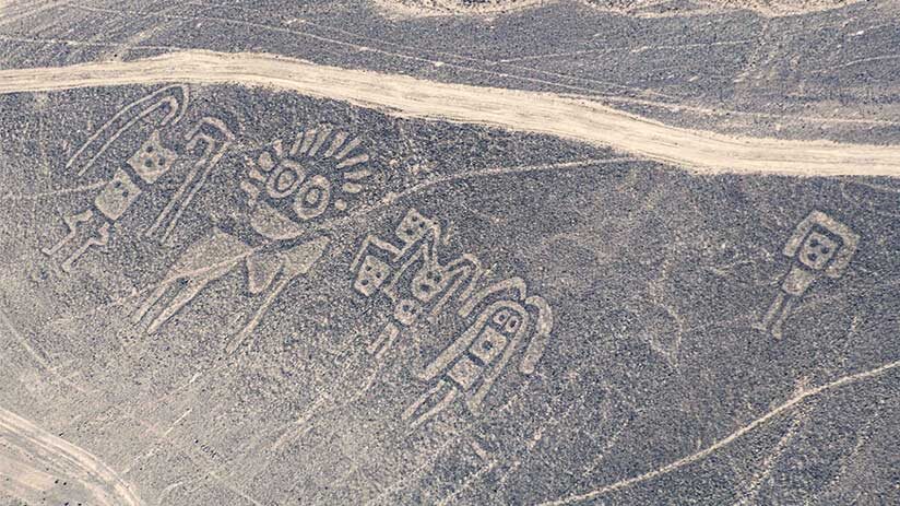
From 2004, a group of researchers led by the professor of archaeologist Masato Sakai of Yamagata university, with the collaboration of the Peruvian archaeologist Jorge Olano and, with the support of the newest IA system, such as the PAIRS geoscope of IBM Chinese multinational, together discovered more than 140 new Nazca lines images (Which were the most deteriorated, almost imperceptible to the human eye) Being a real surprise to the world and increased interest in these wonderful lines. Just in case, if you are wondering if the Nazca Lines are visible in Google Maps, happily the answer is Yes, These are visible, of course not the 300 geoglyphs but at least the most important.
On the other hand, unfortunately, the Nazca lines can not visible from Google Earth because of a low Earth orbit, (300 km high) the 1 km areas extend by approximately 15 degrees or 500 arc seconds. This is slightly above the resolution captured by the human eye. The thickness of the Nazca lines is less than a meter, for this reason, the lines are not visible from Google Earth. For this reason, you have images and an explanation of these images here.
10. The Humanoid
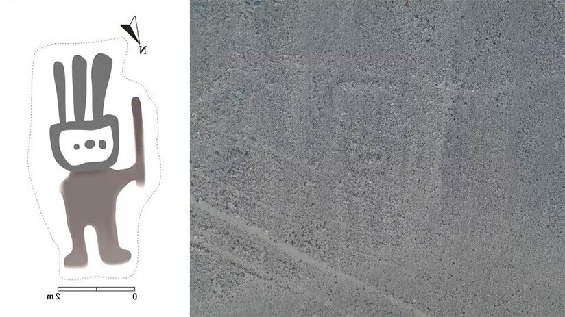
Without a doubt, some of the most awesome images recently found is the Humanoid. This little human of 2 meters (6.6 feet) wide and 4 meters (13.1 feet) tall is one of the smallest found in the area. The image represents a little human holding a scepter with a kind of three-pointed headdress on his rectangular head. This image was very difficult to find, even for the Artificial Intelligence system, given the degree of its deterioration. Therefore, the IA system and the trained eyes of the archaeologists in charge were able to find its location and find it. And the effort was well worth it.
11. The Cat
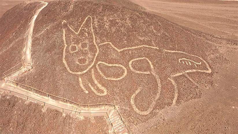
Practically, current tourists passed next to this figure every day without realizing it and it is that the image, recently discovered in 2020, was on a mound of a natural viewpoint near the lines. This cat with pointy ears, large round eyes, a long striped tail, and an open mouth has a length of 31 meters or 121 feet and shows an attitude of wonder. Unusual, within the general characteristics of the Nazca figures. Without mentioning that this Cat was found already in ceramics and fabrics belongings of Nazca culture. For this reason, and according to the carbon 14 dating method, this image could have been made between 200 – 100 B.C. In other words, the Nazca cat is older than many of the surrounding Nazca figures, just amazing!
“TRAVEL IS FATAL TO PREJUDICE, BIGOTRY, AND NARROW-MINDEDNESS”
We hope together with the experts of Machu Travel Peru to have been of help for your next trip to the south Peruvian desert, find the best things to do in Nazca, and be able to better appreciate the famous lines. Keep in mind that these are not all images, they are just some of the most recognizable. But from the air, you can get an idea of the titanic work that ancient Peruvian civilizations undertook. If you are looking to know more about our tours of the lines, do not hesitate to consult with our qualified advisors. We will be delighted to assist you.